
Make a donation
Gear up for your next adventure:
As an Amazon Associate, this site earns from qualifying purchases at no extra cost to you.
Deep River topographic map
Click on the map to display elevation.
Make a donation
Gear up for your next adventure:
As an Amazon Associate, this site earns from qualifying purchases at no extra cost to you.
Deep River
John Bland, an architecture professor at McGill University, developed the town's first master plan in 1944. Bland located the town between the existing Highway 17 and the Ottawa River. He designed a system of streets which generally followed the contours of the area's topography. Residential neighborhoods stretched out from a commercial and service-sector core. Straight and broad avenues ran along contour lines, while narrower and winding streets lay at right angles, discouraging non-local traffic from entering neighborhoods. Parks and schools were scattered strategically throughout the town. The streets were named after local flora, Canadian politicians and famous scientists such as Rutherford and Darwin.
Make a donation
Gear up for your next adventure:
As an Amazon Associate, this site earns from qualifying purchases at no extra cost to you.
About this map
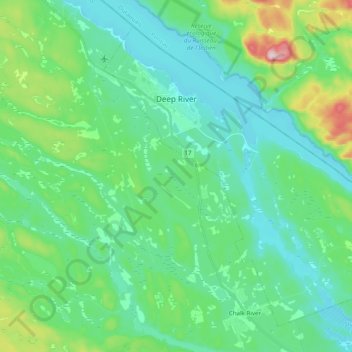
Name: Deep River topographic map, elevation, terrain.
Average elevation: 169 m
Minimum elevation: 103 m
Maximum elevation: 411 m
Make a donation
Gear up for your next adventure:
As an Amazon Associate, this site earns from qualifying purchases at no extra cost to you.