
Thank you for supporting this site ❤️
Make a donation
Make a donation
Gear up for your next adventure:
As an Amazon Associate, this site earns from qualifying purchases at no extra cost to you.
Baramulla topographic map
Click on the map to display elevation.
Thank you for supporting this site ❤️
Make a donation
Make a donation
Gear up for your next adventure:
As an Amazon Associate, this site earns from qualifying purchases at no extra cost to you.
Baramulla
Baramulla is located at 34.2° N 74.34° E. It has an average elevation of 1,593 meters (5,226 feet).
Thank you for supporting this site ❤️
Make a donation
Make a donation
Gear up for your next adventure:
As an Amazon Associate, this site earns from qualifying purchases at no extra cost to you.
About this map
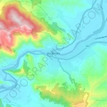
Name: Baramulla topographic map, elevation, terrain.
Location: Baramulla, Jammu and Kashmir, 193101, India (34.04869 74.18350 34.36869 74.50350)
Average elevation: 1,969 m
Minimum elevation: 1,435 m
Maximum elevation: 3,806 m
Thank you for supporting this site ❤️
Make a donation
Make a donation
Gear up for your next adventure:
As an Amazon Associate, this site earns from qualifying purchases at no extra cost to you.