
Bennet topographic map
Interactive map
Click on the map to display elevation.
About this map
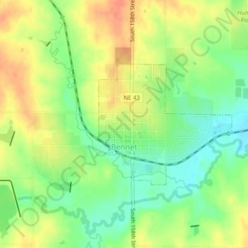
Name: Bennet topographic map, elevation, terrain.
Location: Bennet, Lancaster County, Nebraska, United States (40.67490 -96.51147 40.68805 -96.49234)
Average elevation: 394 m
Minimum elevation: 370 m
Maximum elevation: 417 m
Other topographic maps
Click on a map to view its topography, its elevation and its terrain.
Lincoln
United States > Nebraska > Lancaster County
Lincoln, Lancaster County, Nebraska, United States
Average elevation: 379 m
Waverly
United States > Nebraska > Lancaster County
Waverly, Lancaster County, Nebraska, 68462, United States
Average elevation: 346 m
Hallam
United States > Nebraska > Lancaster County
Hallam, Lancaster County, Nebraska, United States
Average elevation: 447 m
Princeton
United States > Nebraska > Lancaster County
Princeton, Lancaster County, Nebraska, United States
Average elevation: 432 m
Lincoln
United States > Nebraska > Lancaster County > Lincoln
Lincoln, Lancaster County, Nebraska, 68508, United States
Average elevation: 387 m