Geolocate

Caiman topographic map

Interactive map

Click on the map to display elevation.

About this map

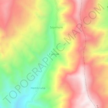
Name: Caiman topographic map, elevation, terrain.

Location: Caiman, La Capilla, Province of General Sánchez Cerro, Moquegua, Peru (-16.72036 -71.18676 -16.68036 -71.14676)

Average elevation: 2,574 m

Minimum elevation: 2,045 m

Maximum elevation: 3,039 m

Other topographic maps

Click on a map to view its topography, its elevation and its terrain.

Sicuani

Peru > Moquegua > Sicuani

Sicuani, General Sánchez Cerro, Moquegua, Peru

Average elevation: 4,124 m

Yanahuara

Peru > Moquegua > Yanahuara

Yanahuara, General Sánchez Cerro, Moquegua, Peru

Average elevation: 2,035 m

Moquegua

Peru > Moquegua > Moquegua

Moquegua, Mariscal Nieto, Moquegua, Peru

Average elevation: 2,080 m

Ilo

Peru > Moquegua > Ilo

Ilo, Moquegua, 18601, Peru

Average elevation: 108 m

La Libertad

Peru > Moquegua > La Libertad

La Libertad, General Sánchez Cerro, Moquegua, Peru

Average elevation: 2,741 m

Loriscota

Peru > Moquegua > Santa Rosa

Loriscota, PU-132, Santa Rosa, El Collao, Moquegua, Peru

Average elevation: 4,580 m