
De Bilt topographic map
Interactive map
Click on the map to display elevation.
De Bilt
Dutch Topographic map of the municipality of De Bilt, June 2015
About this map
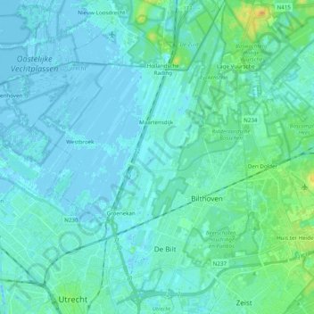
Name: De Bilt topographic map, elevation, terrain.
Location: De Bilt, Utrecht, Netherlands (52.08490 5.09489 52.20427 5.23093)
Average elevation: 4 m
Minimum elevation: -5 m
Maximum elevation: 27 m
Other topographic maps
Click on a map to view its topography, its elevation and its terrain.