
Libertów topographic map
Interactive map
Click on the map to display elevation.
About this map
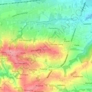
Name: Libertów topographic map, elevation, terrain.
Average elevation: 270 m
Minimum elevation: 223 m
Maximum elevation: 323 m
Other topographic maps
Click on a map to view its topography, its elevation and its terrain.
Werychów
Poland > Lesser Poland Voivodeship > Kraków County > Balice
Werychów, Balice, gmina Zabierzów, Kraków County, Lesser Poland Voivodeship, 31-083, Poland
Average elevation: 238 m
Bielańsko-Tyniecki Park Krajobrazowy
Poland > Lesser Poland Voivodeship > Kraków County > Krakow
Bielańsko-Tyniecki Park Krajobrazowy, Krakow, gmina Liszki, Kraków County, Lesser Poland Voivodeship, Poland
Average elevation: 239 m
Podzamcze
Poland > Lesser Poland Voivodeship > Kraków County > Korzkiew > Podzamcze
Podzamcze, Korzkiew, gmina Zielonki, Kraków County, Lesser Poland Voivodeship, Poland
Average elevation: 321 m
Czernichów
Poland > Lesser Poland Voivodeship > Kraków County
Czernichów, gmina Czernichów, Kraków County, Lesser Poland Voivodeship, Poland
Average elevation: 219 m
Kobylany
Poland > Lesser Poland Voivodeship > Kraków County
Kobylany, gmina Zabierzów, Kraków County, Lesser Poland Voivodeship, Poland
Average elevation: 319 m
Radziszów
Poland > Lesser Poland Voivodeship > Kraków County
Radziszów, gmina Skawina, Kraków County, Lesser Poland Voivodeship, Poland
Average elevation: 262 m