
Cuzcurrita de Río Tirón topographic map
Interactive map
Click on the map to display elevation.
About this map
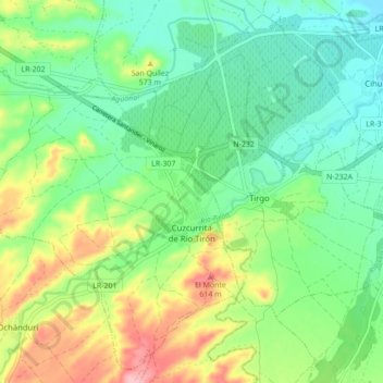
Name: Cuzcurrita de Río Tirón topographic map, elevation, terrain.
Location: Cuzcurrita de Río Tirón, Rioja, 26214, Spain (42.51780 -3.01214 42.57703 -2.92547)
Average elevation: 529 m
Minimum elevation: 479 m
Maximum elevation: 626 m
Other topographic maps
Click on a map to view its topography, its elevation and its terrain.