
Eisenach topographic map
Interactive map
Click on the map to display elevation.
About this map
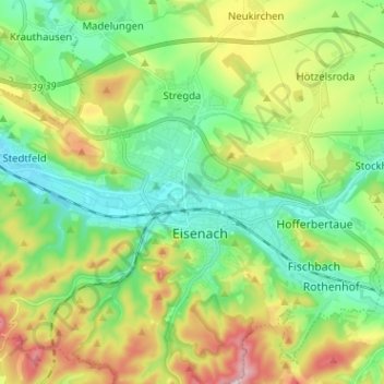
Name: Eisenach topographic map, elevation, terrain.
Location: Eisenach, Thuringia, 99817, Germany (50.94330 10.27670 51.02330 10.35670)
Average elevation: 290 m
Minimum elevation: 202 m
Maximum elevation: 458 m
Other topographic maps
Click on a map to view its topography, its elevation and its terrain.