
Hitchin topographic map
Interactive map
Click on the map to display elevation.
About this map
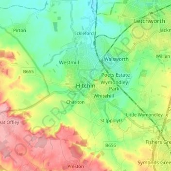
Name: Hitchin topographic map, elevation, terrain.
Average elevation: 89 m
Minimum elevation: 45 m
Maximum elevation: 166 m
Hertfordshire trails, hiking, mountain biking, running and outdoor activities
Other topographic maps
Click on a map to view its topography, its elevation and its terrain.
Knebworth Country Park
United Kingdom > England > Hertfordshire > North Hertfordshire > Knebworth
Average elevation: 116 m
St Paul's Walden
United Kingdom > England > Hertfordshire > North Hertfordshire
Average elevation: 121 m
Knebworth Country Park
United Kingdom > England > Hertfordshire > North Hertfordshire > Knebworth
Average elevation: 116 m
Wymondley
United Kingdom > England > Hertfordshire > North Hertfordshire > Little Wymondley
Average elevation: 96 m
Windmill Hill
United Kingdom > England > Hertfordshire > North Hertfordshire > Hitchin
Average elevation: 74 m