
Marktl topographic map
Interactive map
Click on the map to display elevation.
About this map
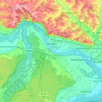
Name: Marktl topographic map, elevation, terrain.
Location: Marktl, Marktl (VGem), Landkreis Altötting, Beieren, Duitsland (48.20355 12.79502 48.29182 12.90121)
Average elevation: 399 m
Minimum elevation: 347 m
Maximum elevation: 506 m
Other topographic maps
Click on a map to view its topography, its elevation and its terrain.
Reichwald
Duitsland > Beieren > Landkreis Altötting > Arbing
Reichwald, Arbing, Reischach, Reischach (VGem), Landkreis Altötting, Beieren, 84571, Duitsland
Average elevation: 462 m