
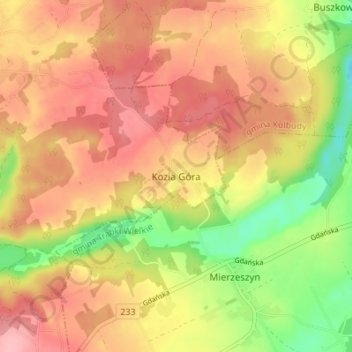
Kozia Góra topographic map
Interactive map
Click on the map to display elevation.
About this map
Name: Kozia Góra topographic map, elevation, terrain.
Average elevation: 222 m
Minimum elevation: 153 m
Maximum elevation: 270 m
Other topographic maps
Click on a map to view its topography, its elevation and its terrain.
Rokitnica
Poland > Pomeranian Voivodeship > Gdańsk County
Rokitnica, gmina Pruszcz Gdański, Gdańsk County, Pomeranian Voivodeship, Poland
Average elevation: 1 m
Ostrowite
Poland > Pomeranian Voivodeship > Gdańsk County
Ostrowite, gmina Pszczółki, Gdańsk County, Pomeranian Voivodeship, Poland
Average elevation: 9 m
Mierzeszyn
Poland > Pomeranian Voivodeship > Gdańsk County
Mierzeszyn, gmina Trąbki Wielkie, Gdańsk County, Pomeranian Voivodeship, 83-041, Poland
Average elevation: 208 m
Przywidz
Poland > Pomeranian Voivodeship > Gdańsk County
Przywidz, gmina Przywidz, Gdańsk County, Pomeranian Voivodeship, 83-047, Poland
Average elevation: 221 m