
Grangetown topographic map
Interactive map
Click on the map to display elevation.
About this map
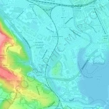
Name: Grangetown topographic map, elevation, terrain.
Location: Grangetown, Cardiff, Wales, United Kingdom (51.44495 -3.20686 51.47738 -3.16176)
Average elevation: 15 m
Minimum elevation: 0 m
Maximum elevation: 95 m
Cardiff trails, hiking, mountain biking, running and outdoor activities
Other topographic maps
Click on a map to view its topography, its elevation and its terrain.