
Thank you for supporting this site ❤️
Make a donation
Make a donation
Gear up for your next adventure:
As an Amazon Associate, this site earns from qualifying purchases at no extra cost to you.
Dom topographic map
Click on the map to display elevation.
Thank you for supporting this site ❤️
Make a donation
Make a donation
Gear up for your next adventure:
As an Amazon Associate, this site earns from qualifying purchases at no extra cost to you.
About this map
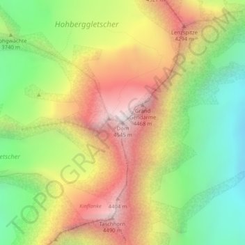
Name: Dom topographic map, elevation, terrain.
Location: Dom, Saas-Fee, Visp, Wallis, 3906, Switzerland (46.09388 7.85882 46.09398 7.85892)
Average elevation: 3,785 m
Minimum elevation: 3,113 m
Maximum elevation: 4,538 m
Thank you for supporting this site ❤️
Make a donation
Make a donation
Gear up for your next adventure:
As an Amazon Associate, this site earns from qualifying purchases at no extra cost to you.