
Thank you for supporting this site ❤️
Make a donation
Make a donation
Gear up for your next adventure:
As an Amazon Associate, this site earns from qualifying purchases at no extra cost to you.
Cheyenne topographic map
Click on the map to display elevation.
Thank you for supporting this site ❤️
Make a donation
Make a donation
Gear up for your next adventure:
As an Amazon Associate, this site earns from qualifying purchases at no extra cost to you.
About this map
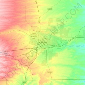
Name: Cheyenne topographic map, elevation, terrain.
Location: Cheyenne, Laramie County, Wyoming, 82002, United States (40.97998 -104.98025 41.29998 -104.66025)
Average elevation: 1,891 m
Minimum elevation: 1,744 m
Maximum elevation: 2,091 m
Thank you for supporting this site ❤️
Make a donation
Make a donation
Gear up for your next adventure:
As an Amazon Associate, this site earns from qualifying purchases at no extra cost to you.
Other topographic maps
Click on a map to view its topography, its elevation and its terrain.
Ranchettes
United States > Wyoming > Laramie County > Cheyenne > Ranchettes
Average elevation: 1,869 m