
City of Vršac topographic map
Interactive map
Click on the map to display elevation.
About this map
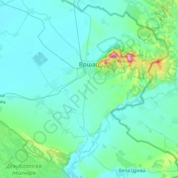
Name: City of Vršac topographic map, elevation, terrain.
Average elevation: 119 m
Minimum elevation: 72 m
Maximum elevation: 613 m
Other topographic maps
Click on a map to view its topography, its elevation and its terrain.
Gudurički vrh
Serbia > Vojvodina > South Banat Administrative District > City of Vršac
Gudurički vrh, City of Vršac, South Banat Administrative District, Vojvodina, 26334, Serbia
Average elevation: 330 m
Zagajica
Serbia > Vojvodina > South Banat Administrative District
Zagajica, South Banat Administrative District, Vojvodina, Serbia
Average elevation: 109 m
Pancevo City
Serbia > Vojvodina > South Banat Administrative District
Pancevo City, South Banat Administrative District, Vojvodina, Serbia
Average elevation: 102 m
Hajducica
Serbia > Vojvodina > South Banat Administrative District > Plandiste Municipality
Hajducica, Plandiste Municipality, South Banat Administrative District, Vojvodina, Serbia
Average elevation: 77 m