
River Leen topographic map
Interactive map
Click on the map to display elevation.
About this map
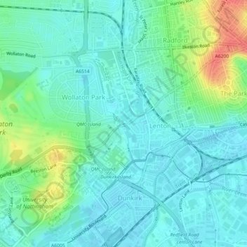
Name: River Leen topographic map, elevation, terrain.
Average elevation: 39 m
Minimum elevation: 25 m
Maximum elevation: 80 m
Other topographic maps
Click on a map to view its topography, its elevation and its terrain.
River Leen
United Kingdom > England > City of Nottingham
River Leen, City of Nottingham, East Midlands, England, NG6 8EU, United Kingdom
Average elevation: 63 m
Balloon Wood
United Kingdom > England > City of Nottingham
Balloon Wood, Wollaton Vale, City of Nottingham, East Midlands, England, NG8 2JA, United Kingdom
Average elevation: 71 m
Strelley Recreation Ground
United Kingdom > England > City of Nottingham
Strelley Recreation Ground, Bilborough, City of Nottingham, East Midlands, England, United Kingdom
Average elevation: 93 m