
Moosic topographic map
Interactive map
Click on the map to display elevation.
About this map
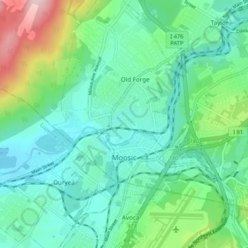
Name: Moosic topographic map, elevation, terrain.
Average elevation: 246 m
Minimum elevation: 166 m
Maximum elevation: 505 m
Other topographic maps
Click on a map to view its topography, its elevation and its terrain.
Madisonville
United States > Pennsylvania > Lackawanna County > Madison Township
Average elevation: 512 m
Spring Brook
United States > Pennsylvania > Lackawanna County > Spring Brook Township
Average elevation: 463 m
Mount Cobb
United States > Pennsylvania > Lackawanna County > Jefferson Township
Average elevation: 529 m
Birchwood Estates
United States > Pennsylvania > Lackawanna County > Roaring Brook Township
Average elevation: 512 m
Elmhurst
United States > Pennsylvania > Lackawanna County > Elmhurst Township
Average elevation: 478 m
Eagle Lake
United States > Pennsylvania > Lackawanna County > Covington Township
Average elevation: 578 m