
Make a donation
Gear up for your next adventure:
As an Amazon Associate, this site earns from qualifying purchases at no extra cost to you.
Kittatinny Mountain topographic map
Click on the map to display elevation.
Make a donation
Gear up for your next adventure:
As an Amazon Associate, this site earns from qualifying purchases at no extra cost to you.
Kittatinny Mountain
Kittatinny Mountain (Lenape: Kitahtëne) is a long ridge traversing primarily across Sussex County in northwestern New Jersey, running in a northeast-southwest axis, a continuation across the Delaware Water Gap of Pennsylvania's Blue Mountain (also known as Kittatinny Ridge). It is the first major ridge in the far northeastern extension of the Ridge and Valley province of the Appalachian Mountains, and reaches its highest elevation (the state's highest), 1,803 feet, at High Point in Montague Township. Kittatinny Mountain forms the eastern side of Wallpack Valley; the western side comprises the Wallpack Ridge (highest elevation: 928 feet (283 m) above sea level.
Make a donation
Gear up for your next adventure:
As an Amazon Associate, this site earns from qualifying purchases at no extra cost to you.
About this map
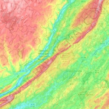
Name: Kittatinny Mountain topographic map, elevation, terrain.
Average elevation: 266 m
Minimum elevation: 90 m
Maximum elevation: 522 m
Make a donation
Gear up for your next adventure:
As an Amazon Associate, this site earns from qualifying purchases at no extra cost to you.
Other topographic maps
Click on a map to view its topography, its elevation and its terrain.
Vernon Township
United States > New Jersey > Sussex County
Elevation varies greatly due to the valleys, rolling hills, and mountains. The United States Geological Survey places Glenwood at 580 feet (180 m), McAfee at 435 feet (133 m), and Highland Lakes at 1,260 feet (380 m).
Average elevation: 253 m
Stillwater Township
United States > New Jersey > Sussex County
Flanked to the west by Kittatinny Mountain, the Stillwater Township is located within the Ridge and Valley Physiographic Province, and the entire township is within the Kittatinny Valley a region of rolling hills and flat valley floors that is a section of the larger Great Appalachian Valley running 700 miles…
Average elevation: 244 m
Make a donation
Gear up for your next adventure:
As an Amazon Associate, this site earns from qualifying purchases at no extra cost to you.
Newton
United States > New Jersey > Sussex County
Because of its location in the higher elevations of northwestern New Jersey's Appalachian mountains, Newton, as well as the rest of Sussex County, has a cooler humid continental climate or microthermal climate (Köppen climate classification Dfb) which indicates patterns of significant precipitation in all…
Average elevation: 202 m
Make a donation
Gear up for your next adventure:
As an Amazon Associate, this site earns from qualifying purchases at no extra cost to you.
Stillwater Township
United States > New Jersey > Sussex County
Flanked to the west by Kittatinny Mountain, the Stillwater Township is located within the Ridge and Valley Physiographic Province, and the entire township is within the Kittatinny Valley a region of rolling hills and flat valley floors that is a section of the larger Great Appalachian Valley running 700 miles…
Average elevation: 244 m
Make a donation
Gear up for your next adventure:
As an Amazon Associate, this site earns from qualifying purchases at no extra cost to you.
High Point State Park
United States > New Jersey > Sussex County > Montague Township
High Point State Park is a state park straddling the border of Wantage Township and Montague Township in Sussex County, within the Skylands Region of northwestern New Jersey, United States, near the border with New York State and Pennsylvania. The park covers 15,413 acres (62.37 km2). Part of the Kittatinny…
Average elevation: 257 m
Stokes State Forest
United States > New Jersey > Sussex County > Sandyston Township
The pavilion at the top of the peak makes a great place to picnic. To make traveling to Sunrise more interesting, one can look for the New Jersey shaped rock. The mountain is the second highest point in New Jersey, being 1,653 feet (504 m) above sea level. Hikers are amazed with the view. There is a USGS…
Average elevation: 260 m
Make a donation
Gear up for your next adventure:
As an Amazon Associate, this site earns from qualifying purchases at no extra cost to you.
Make a donation
Gear up for your next adventure:
As an Amazon Associate, this site earns from qualifying purchases at no extra cost to you.
High Point
United States > New Jersey > Sussex County > Montague Township
High Point is a mountain peak within High Point State Park on the border of Wantage Township and Montague Township, Sussex County, New Jersey. Located in the portion of the state known as the Skylands, it is the highest elevation in the state, with a peak elevation of 1,803 feet (550 m). The closest city is…
Average elevation: 415 m
Make a donation
Gear up for your next adventure:
As an Amazon Associate, this site earns from qualifying purchases at no extra cost to you.
Make a donation
Gear up for your next adventure:
As an Amazon Associate, this site earns from qualifying purchases at no extra cost to you.
Make a donation
Gear up for your next adventure:
As an Amazon Associate, this site earns from qualifying purchases at no extra cost to you.
Vernon Township
United States > New Jersey > Sussex County
Elevation varies greatly due to the valleys, rolling hills, and mountains. The United States Geological Survey places Glenwood at 580 feet (180 m), McAfee at 435 feet (133 m), and Highland Lakes at 1,260 feet (380 m).
Average elevation: 253 m
Halsey
United States > New Jersey > Sussex County > Hampton Township > Hampton Township
Average elevation: 186 m
Make a donation
Gear up for your next adventure:
As an Amazon Associate, this site earns from qualifying purchases at no extra cost to you.
Hampton Township
United States > New Jersey > Sussex County > Hampton Township
Average elevation: 202 m
High Point State Park
United States > New Jersey > Sussex County > Montague Township
High Point State Park is a state park straddling the border of Wantage Township and Montague Township in Sussex County, within the Skylands Region of northwestern New Jersey, United States, near the border with New York State and Pennsylvania. The park covers 15,413 acres (62.37 km2). Part of the Kittatinny…
Average elevation: 255 m
Make a donation
Gear up for your next adventure:
As an Amazon Associate, this site earns from qualifying purchases at no extra cost to you.
Montague Township
United States > New Jersey > Sussex County
Montague Township is a township in Sussex County, in the U.S. state of New Jersey, in the New York City Metropolitan Area. As of the 2020 United States census, the township's population was 3,792, a decrease of 55 (−1.4%) from the 2010 census count of 3,847, which in turn reflected an increase of 435…
Average elevation: 254 m
Make a donation
Gear up for your next adventure:
As an Amazon Associate, this site earns from qualifying purchases at no extra cost to you.
High Point
United States > New Jersey > Sussex County > Montague Township
High Point is a mountain peak within High Point State Park on the border of Wantage Township and Montague Township, Sussex County, New Jersey, United States. Located in the portion of the state known as the Skylands, it is the highest elevation in the state, with a peak elevation of 1,803 feet (550 m). The…
Average elevation: 415 m
Make a donation
Gear up for your next adventure:
As an Amazon Associate, this site earns from qualifying purchases at no extra cost to you.
Montague
United States > New Jersey > Sussex County > Montague Township > Montague
Average elevation: 178 m
Stillwater Township
United States > New Jersey > Sussex County
Flanked to the west by Kittatinny Mountain, the Stillwater Township is located within the Ridge and Valley Physiographic Province, and the entire township is within the Kittatinny Valley a region of rolling hills and flat valley floors that is a section of the larger Great Appalachian Valley running 700 miles…
Average elevation: 244 m
Wallpack Center
United States > New Jersey > Sussex County > Wallpack Township
Average elevation: 179 m
Make a donation
Gear up for your next adventure:
As an Amazon Associate, this site earns from qualifying purchases at no extra cost to you.
Newton
United States > New Jersey > Sussex County
Because of its location in the higher elevations of northwestern New Jersey's Appalachian mountains, Newton, as well as the rest of Sussex County, has a cooler humid continental climate or microthermal climate (Köppen climate classification Dfb) which indicates patterns of significant precipitation in all…
Average elevation: 202 m
Make a donation
Gear up for your next adventure:
As an Amazon Associate, this site earns from qualifying purchases at no extra cost to you.
Make a donation
Gear up for your next adventure:
As an Amazon Associate, this site earns from qualifying purchases at no extra cost to you.
Montague Township
United States > New Jersey > Sussex County
Montague Township is a township in Sussex County, in the U.S. state of New Jersey, in the New York City Metropolitan Area. As of the 2020 United States census, the township's population was 3,792, a decrease of 55 (−1.4%) from the 2010 census count of 3,847, which in turn reflected an increase of 435…
Average elevation: 254 m