
Make a donation
Gear up for your next adventure:
As an Amazon Associate, this site earns from qualifying purchases at no extra cost to you.
Bentonville topographic map
Click on the map to display elevation.
Make a donation
Gear up for your next adventure:
As an Amazon Associate, this site earns from qualifying purchases at no extra cost to you.
Bentonville
Bentonville lies in the humid subtropical climate zone (Köppen Cfa) with influence from the humid continental climate type. Bentonville experiences all four seasons and does receive cold air masses from the north, however some of the Arctic masses are blocked by the higher elevations of the Ozarks. July is the hottest month of the year, with an average high of 89 °F (32 °C) and an average low of 66 °F (19 °C). Temperatures above 100 °F (37.8 °C) are common, with recent temperatures during summer months staying above 100 degrees for several weeks at a time. January is the coldest month with an average high of 46 °F (8 °C) and an average low of 24 °F (−4 °C). The city's highest temperature was 114 °F (45.6 °C), recorded in 1954. The lowest temperature recorded was −16 °F (−26.7 °C), in 1996.
Make a donation
Gear up for your next adventure:
As an Amazon Associate, this site earns from qualifying purchases at no extra cost to you.
About this map
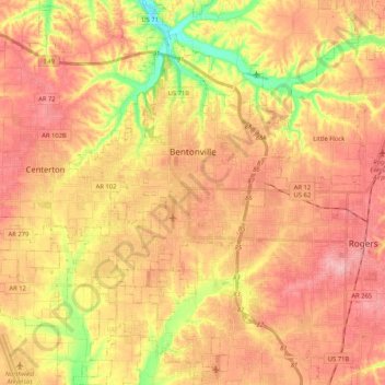
Name: Bentonville topographic map, elevation, terrain.
Location: Bentonville, Benton County, Arkansas, United States (36.27106 -94.32624 36.43867 -94.15459)
Average elevation: 387 m
Minimum elevation: 309 m
Maximum elevation: 436 m
Make a donation
Gear up for your next adventure:
As an Amazon Associate, this site earns from qualifying purchases at no extra cost to you.
Other topographic maps
Click on a map to view its topography, its elevation and its terrain.
Bentonville
United States > Arkansas > Benton County > Bentonville > Bentonville
Bentonville lies in the humid subtropical climate zone (Köppen Cfa) with influence from the humid continental climate type. Bentonville experiences all four seasons and does receive cold air masses from the north, however some of the Arctic masses are blocked by the higher elevations of the Ozarks. July is…
Average elevation: 383 m
Make a donation
Gear up for your next adventure:
As an Amazon Associate, this site earns from qualifying purchases at no extra cost to you.
Make a donation
Gear up for your next adventure:
As an Amazon Associate, this site earns from qualifying purchases at no extra cost to you.
Blowing Springs Bike & Fitness Park
United States > Arkansas > Benton County > Bella Vista
Average elevation: 351 m