
Cheruthapullur Kulam topographic map
Interactive map
Click on the map to display elevation.
About this map
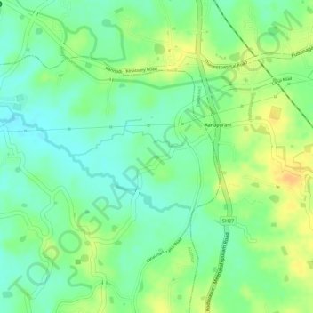
Name: Cheruthapullur Kulam topographic map, elevation, terrain.
Average elevation: 90 m
Minimum elevation: 75 m
Maximum elevation: 107 m
Other topographic maps
Click on a map to view its topography, its elevation and its terrain.
Mathoor
India > Kerala > Alathur > Kuzhalmannam
Mathoor, Kuzhalmannam, Alathur, Palakkad District, Kerala, 678571, India
Average elevation: 75 m
Vadakkenchery
Vadakkenchery, Alathur, Palakkad District, Kerala, 678684, India
Average elevation: 68 m
Malappuram
Malappuram, Alathur, Palakkad district, Kerala, India
Average elevation: 76 m