Geolocate

Hà Tĩnh topographic map

Interactive map

Click on the map to display elevation.

About this map

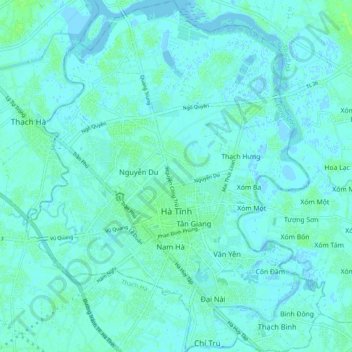
Name: Hà Tĩnh topographic map, elevation, terrain.

Location: Hà Tĩnh, Hà Tĩnh Province, 45100, Vietnam (18.30803 105.86000 18.40081 105.94334)

Average elevation: 3 m

Minimum elevation: -3 m

Maximum elevation: 10 m

Other topographic maps

Click on a map to view its topography, its elevation and its terrain.

Hương Khê District

Vietnam > Ha Tinh Province

Hương Khê District, Hà Tĩnh Province, 46003, Vietnam

Average elevation: 262 m

Can Lộc District

Vietnam > Ha Tinh Province

Can Lộc District, Ha Tinh Province, Vietnam

Average elevation: 39 m

Vĩnh Phúc

Vietnam > Ha Tinh Province > Vĩnh Phúc

Vĩnh Phúc, Can Lộc District, Ha Tinh Province, Vietnam

Average elevation: 13 m

Hương Sơn District

Vietnam > Ha Tinh Province

Hương Sơn District, Ha Tinh Province, Vietnam

Average elevation: 513 m