
Colwood topographic map
Interactive map
Click on the map to display elevation.
About this map
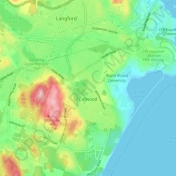
Name: Colwood topographic map, elevation, terrain.
Average elevation: 64 m
Minimum elevation: -1 m
Maximum elevation: 219 m
Other topographic maps
Click on a map to view its topography, its elevation and its terrain.
Mary's Peak
Canada > British Columbia > Capital Regional District > Juan de Fuca Electoral Area
Average elevation: 458 m
Mount Erskine
Canada > British Columbia > Capital Regional District > Salt Spring Island Electoral Area
Average elevation: 233 m
Shirley
Canada > British Columbia > Capital Regional District > Juan de Fuca Electoral Area > Shirley
Average elevation: 79 m