
Usak topographic map
Interactive map
Click on the map to display elevation.
About this map
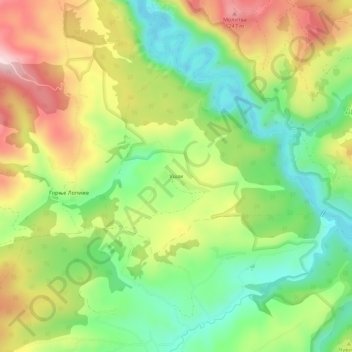
Name: Usak topographic map, elevation, terrain.
Average elevation: 1,095 m
Minimum elevation: 964 m
Maximum elevation: 1,267 m
Other topographic maps
Click on a map to view its topography, its elevation and its terrain.
Ђаловића клисура
Serbia > Central Serbia > Zlatibor Administrative District > Sjenica Municipality > Crvsko
Average elevation: 1,091 m
Sjenica
Serbia > Central Serbia > Zlatibor Administrative District > Sjenica Municipality
Sjenica is located at an altitude of 1,026 meters above sea level, making it one of the highest towns in Serbia and the Balkans. Temperatures fall below freezing on average 134 days per year, with the first freeze in late September and the last in early May.
Average elevation: 1,075 m
Duga Poljana
Serbia > Central Serbia > Zlatibor Administrative District > Sjenica Municipality
Average elevation: 1,132 m
Sjenica
Serbia > Central Serbia > Zlatibor Administrative District > Sjenica Municipality
Sjenica is located at an altitude of 1,026 meters above sea level, making it one of the highest towns in Serbia and the Balkans. Temperatures fall below freezing on average 134 days per year, with the first freeze in late September and the last in early May.
Average elevation: 1,075 m