
Karurumo topographic map
Interactive map
Click on the map to display elevation.
About this map
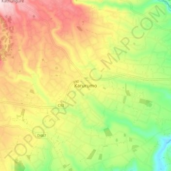
Name: Karurumo topographic map, elevation, terrain.
Location: Karurumo, Embu, East Kenya, Kenya (-0.51307 37.61079 -0.43307 37.69079)
Average elevation: 1,229 m
Minimum elevation: 1,064 m
Maximum elevation: 1,400 m
Other topographic maps
Click on a map to view its topography, its elevation and its terrain.
Mount Kenya
The glaciers on Mount Kenya are retreating rapidly. The Mountain Club of Kenya in Nairobi has photographs showing the mountain at the time of the first recorded ascent in 1899, and again more recently; the retreat of the glaciers is very evident. Descriptions of ascents of several of the peaks advise the use…
Average elevation: 4,556 m