
Brockenberg topographic map
Interactive map
Click on the map to display elevation.
About this map
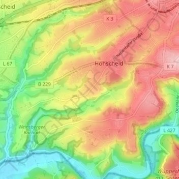
Name: Brockenberg topographic map, elevation, terrain.
Average elevation: 150 m
Minimum elevation: 64 m
Maximum elevation: 233 m
Other topographic maps
Click on a map to view its topography, its elevation and its terrain.
Stöcken
Deutschland > Nordrhein-Westfalen > Solingen
Stöcken, Solingen-Mitte, Solingen, Nordrhein-Westfalen, 42651, Deutschland
Average elevation: 204 m
Höhscheid/Burg
Deutschland > Nordrhein-Westfalen > Solingen
Höhscheid/Burg, Solingen, Regierungsbezirk Düsseldorf, Nordrhein-Westfalen, Deutschland
Average elevation: 178 m