
Coleville topographic map
Interactive map
Click on the map to display elevation.
Coleville
Coleville is an unincorporated community and census-designated place (CDP) in Mono County, California, United States. It is located at an elevation of 5,141 feet (1,567 m) in the Antelope Valley on the West Walker River. The population was 419 at the 2020 census, down from 495 at the 2010 census.
About this map
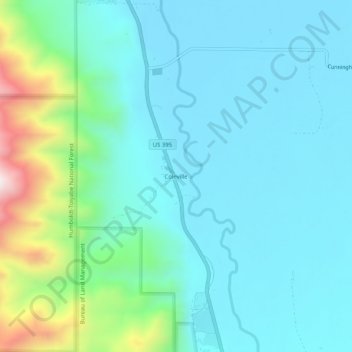
Name: Coleville topographic map, elevation, terrain.
Location: Coleville, Mono County, California, United States (38.54630 -119.52711 38.58630 -119.48711)
Average elevation: 1,683 m
Minimum elevation: 1,546 m
Maximum elevation: 2,272 m
Other topographic maps
Click on a map to view its topography, its elevation and its terrain.
Mammoth Lakes
United States > California > Mono County
Mammoth Lakes is a town in Mono County, California, and is the county's only incorporated community. It is located immediately to the east of Mammoth Mountain, at an elevation of 7,880 feet (2,400 m). As of the 2020 United States Census, the population was 7,191, reflecting a 12.7% decrease from the 2010…
Average elevation: 2,682 m
Mono Lake
United States > California > Mono County
Lake Russell was the prehistoric predecessor to Mono Lake, during the Pleistocene. Its shoreline reached the modern-day elevation of 7,480 feet (2,280 m), about 1,100 feet (330 m) higher than the present-day lake. As of 1.6 million years ago, Lake Russell discharged to the northeast, into the Walker River…
Average elevation: 2,008 m
June Lake
United States > California > Mono County > June Lake
June Lake is a census-designated place in Mono County, California. It is located against the southern rim of the Mono Basin, 12.5 miles (20 km) south of Lee Vining, at an elevation of 7654 feet (2333 m).
Average elevation: 2,445 m
Mammoth Lakes
United States > California > Mono County
Mammoth Lakes is a town in Mono County, California, and is the county's only incorporated community. It is located immediately to the east of Mammoth Mountain, at an elevation of 7,880 feet (2,400 m). As of the 2020 United States Census, the population was 7,191, reflecting a 12.7% decrease from the 2010…
Average elevation: 2,682 m