
Zarewo topographic map
Interactive map
Click on the map to display elevation.
About this map
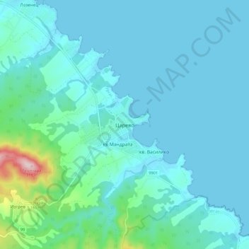
Name: Zarewo topographic map, elevation, terrain.
Location: Zarewo, Oblast Burgas, 8260, Bulgarien (42.13028 27.80829 42.21028 27.88829)
Average elevation: 38 m
Minimum elevation: -1 m
Maximum elevation: 321 m
Die Stadt Zarewo befindet sich am Fuße des Strandscha-Gebirges. Sie liegt auf drei kleinen Halbinseln und vier Buchten, 15 km nordöstlich von Achtopol und 64 km südöstlich des regionalen Zentrums von Burgas. Die Küstenlinie ist stark gegliedert und wechselt zwischen felsigen Halbinseln und kleinen malerischen Stränden. Südlich der Stadt erhebt sich der Papia-Gipfel des Strandscha-Gebirges. mit einer Höhe von 502 m.
Other topographic maps
Click on a map to view its topography, its elevation and its terrain.
Sweti Wlas
Sweti Wlas, Несебър, Oblast Burgas, 8256, Bulgarien
Average elevation: 119 m
Nessebar
Nessebar, Несебър, Oblast Burgas, 8230, Bulgarien
Average elevation: 4 m
Burgas
Bulgarien > Oblast Burgas > Burgas
Burgas, Oblast Burgas, 8000, Bulgarien
Average elevation: 42 m