
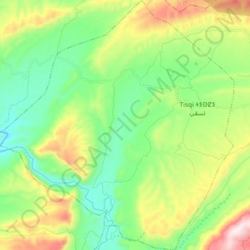
Tisqi topographic map
Interactive map
Click on the map to display elevation.
About this map
Name: Tisqi topographic map, elevation, terrain.
Average elevation: 724 m
Minimum elevation: 468 m
Maximum elevation: 1,246 m
Other topographic maps
Click on a map to view its topography, its elevation and its terrain.
Bni Hassane
Bni Hassane, caïdat de Foum Jemaâ, cercle de Bzou, Province d'Azilal, Béni Mellal-Khénifra, Maroc
Average elevation: 733 m
Moulay Aissa Ben Driss
Moulay Aissa Ben Driss, caïdat d'Aït Aatab, cercle de Bzou, Province d'Azilal, Béni Mellal-Khénifra, 22102, Maroc
Average elevation: 860 m
Rfala
Rfala, caïdat de Bzou, cercle de Bzou, Province d'Azilal, Béni Mellal-Khénifra, Maroc
Average elevation: 579 m
Tabia
Tabia, caïdat de Foum Jemaâ, cercle de Bzou, Province d'Azilal, Béni Mellal-Khénifra, 22352, Maroc
Average elevation: 896 m
Tanant
Tanant, caïdat de Tanant, cercle de Bzou, Province d'Azilal, Béni Mellal-Khénifra, 22552, Maroc
Average elevation: 867 m
Taounza
Taounza, caïdat d'Aït Aatab, cercle de Bzou, Province d'Azilal, Béni Mellal-Khénifra, Maroc
Average elevation: 1,085 m
Foum Jemaa
Foum Jemaa, caïdat de Foum Jemaâ, cercle de Bzou, Province d'Azilal, Béni Mellal-Khénifra, 22353, Maroc
Average elevation: 822 m
Bzou
Bzou, caïdat de Bzou, cercle de Bzou, Province d'Azilal, Béni Mellal-Khénifra, 22250, Maroc
Average elevation: 533 m