
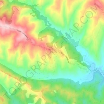
Τόξο topographic map
Interactive map
Click on the map to display elevation.
About this map
Name: Τόξο topographic map, elevation, terrain.
Average elevation: 236 m
Minimum elevation: 130 m
Maximum elevation: 370 m
Other topographic maps
Click on a map to view its topography, its elevation and its terrain.
Παλαιό Κεραμίδι
Greece > Macedonia and Thrace > Pieria Regional Unit > Katerini Municipality
Average elevation: 114 m
Olympiaki Akti (Beach)
Greece > Macedonia and Thrace > Pieria Regional Unit > Katerini Municipality
Average elevation: 2 m
Paralia
Greece > Macedonia and Thrace > Pieria Regional Unit > Katerini Municipality
Average elevation: 5 m
Άγιος Δημήτριος
Greece > Macedonia and Thrace > Pieria Regional Unit > Katerini Municipality
Average elevation: 1,010 m
Πέλεκας
Greece > Macedonia and Thrace > Pieria Regional Unit > Katerini Municipality > Αρωνάς
Average elevation: 140 m
Ράχη
Greece > Macedonia and Thrace > Pieria Regional Unit > Katerini Municipality
Average elevation: 202 m