
Make a donation
Gear up for your next adventure:
As an Amazon Associate, this site earns from qualifying purchases at no extra cost to you.
Rewalsar topographic map
Click on the map to display elevation.
Make a donation
Gear up for your next adventure:
As an Amazon Associate, this site earns from qualifying purchases at no extra cost to you.
Rewalsar
Rewalsar is located at an altitude of 1360 m above sea level. It is connected to Mandi by a motorable road and is about 25 km from Mandi. Lying in the Southern Himalayan belt, winters in Rewalsar can be freezing, while summers are generally pleasant.
Make a donation
Gear up for your next adventure:
As an Amazon Associate, this site earns from qualifying purchases at no extra cost to you.
About this map
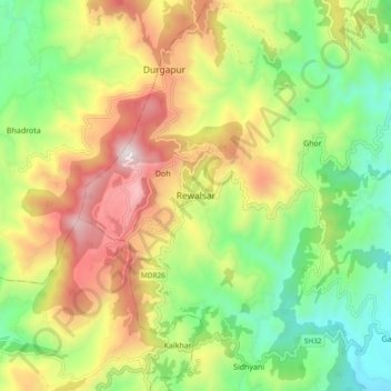
Name: Rewalsar topographic map, elevation, terrain.
Location: Rewalsar, Mandi, Himachal Pradesh, 175023, India (31.59248 76.79330 31.67248 76.87330)
Average elevation: 1,283 m
Minimum elevation: 814 m
Maximum elevation: 1,927 m
Make a donation
Gear up for your next adventure:
As an Amazon Associate, this site earns from qualifying purchases at no extra cost to you.
Other topographic maps
Click on a map to view its topography, its elevation and its terrain.