
Thank you for supporting this site ❤️
Make a donation
Make a donation
Gear up for your next adventure:
As an Amazon Associate, this site earns from qualifying purchases at no extra cost to you.
Gorafe topographic map
Click on the map to display elevation.
Thank you for supporting this site ❤️
Make a donation
Make a donation
Gear up for your next adventure:
As an Amazon Associate, this site earns from qualifying purchases at no extra cost to you.
About this map
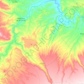
Name: Gorafe topographic map, elevation, terrain.
Location: Gorafe, Comarca de Guadix, Granada, Andalusia, 18890, Spain (37.44342 -3.10394 37.59087 -2.97793)
Average elevation: 816 m
Minimum elevation: 543 m
Maximum elevation: 1,124 m
Thank you for supporting this site ❤️
Make a donation
Make a donation
Gear up for your next adventure:
As an Amazon Associate, this site earns from qualifying purchases at no extra cost to you.