Geolocate

Bwishyura topographic map

Interactive map

Click on the map to display elevation.

About this map

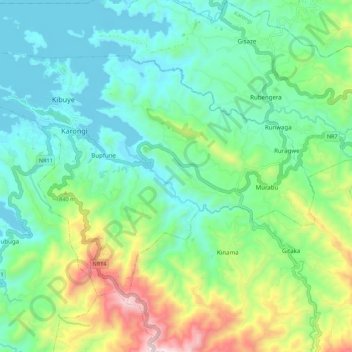
Name: Bwishyura topographic map, elevation, terrain.

Location: Bwishyura, Karongi, Western Province, Rwanda (-2.12363 29.31763 -2.04471 29.42655)

Average elevation: 1,711 m

Minimum elevation: 1,452 m

Maximum elevation: 2,398 m

Other topographic maps

Click on a map to view its topography, its elevation and its terrain.

Rubengera

Rwanda > Western Province > Karongi

Rubengera, Karongi, Western Province, Rwanda

Average elevation: 1,830 m

Mubuga

Rwanda > Western Province > Karongi > Mubuga

Mubuga, Karongi, Western Province, Rwanda

Average elevation: 1,607 m