
Awārān District topographic map
Interactive map
Click on the map to display elevation.
About this map
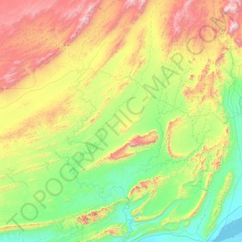
Name: Awārān District topographic map, elevation, terrain.
Location: Awārān District, Balochistan, Pakistan (25.46667 64.80000 26.86667 66.20000)
Average elevation: 518 m
Minimum elevation: -2 m
Maximum elevation: 1,831 m
Other topographic maps
Click on a map to view its topography, its elevation and its terrain.
Jhal Jhao
Pakistan > Balochistan > Awaran District > Jhal Jhao
Jhal Jhao, Awaran District, Balochistan, Pakistan
Average elevation: 352 m
Wadi
Pakistan > Balochistan > Awaran District
Wadi, Awaran District, Balochistan, Pakistan
Average elevation: 647 m