
2e Haut du Cap topographic map
Interactive map
Click on the map to display elevation.
About this map
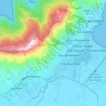
Name: 2e Haut du Cap topographic map, elevation, terrain.
Average elevation: 158 m
Minimum elevation: 0 m
Maximum elevation: 798 m
Other topographic maps
Click on a map to view its topography, its elevation and its terrain.
3e Petite Anse
Haiti > Département du Nord > Commune Cap-Haïtien
3e Petite Anse, Commune Cap-Haïtien, Arrondissement de Cap-Haïtien, Département du Nord, Haiti
Average elevation: 20 m