
Thank you for supporting this site ❤️
Make a donation
Make a donation
Gear up for your next adventure:
As an Amazon Associate, this site earns from qualifying purchases at no extra cost to you.
Crodo topographic map
Click on the map to display elevation.
Thank you for supporting this site ❤️
Make a donation
Make a donation
Gear up for your next adventure:
As an Amazon Associate, this site earns from qualifying purchases at no extra cost to you.
About this map
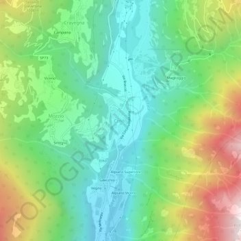
Name: Crodo topographic map, elevation, terrain.
Location: Crodo, Verbano-Cusio-Ossola, Piemonte, 28862, Italia (46.20330 8.30394 46.24330 8.34394)
Average elevation: 911 m
Minimum elevation: 406 m
Maximum elevation: 1,923 m
Thank you for supporting this site ❤️
Make a donation
Make a donation
Gear up for your next adventure:
As an Amazon Associate, this site earns from qualifying purchases at no extra cost to you.