
Annoville topographic map
Interactive map
Click on the map to display elevation.
About this map
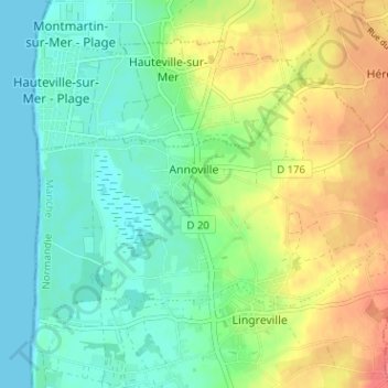
Name: Annoville topographic map, elevation, terrain.
Average elevation: 22 m
Minimum elevation: 0 m
Maximum elevation: 60 m
Other topographic maps
Click on a map to view its topography, its elevation and its terrain.
Lingreville
France > Normandie > Manche > Tourneville-sur-Mer
Lingreville, Tourneville-sur-Mer, Coutances, Manche, Normandie, France métropolitaine, 50660, France
Average elevation: 26 m
Ham Renouf
France > Normandie > Manche > Tourneville-sur-Mer > Lingreville
Ham Renouf, Lingreville, Tourneville-sur-Mer, Coutances, Manche, Normandie, France métropolitaine, 50660, France
Average elevation: 23 m