Geolocate

Muleshoe topographic map

Click on the map to display elevation.

About this map
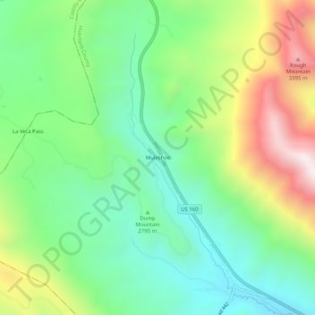
Name: Muleshoe topographic map, elevation, terrain.

Location: Muleshoe, Huerfano County, Colorado, United States (37.56973 -105.20250 37.60973 -105.16250)

Average elevation: 2,882 m

Minimum elevation: 2,553 m

Maximum elevation: 3,489 m

Other topographic maps

Click on a map to view its topography, its elevation and its terrain.
Walsenburg

United States > Colorado > Huerfano County

Average elevation: 1,899 m

La Veta

United States > Colorado > Huerfano County

Average elevation: 2,157 m

La Veta

United States > Colorado > Huerfano County

Average elevation: 2,157 m

La Veta

United States > Colorado > Huerfano County

Average elevation: 2,157 m

Bear Lake

United States > Colorado > Huerfano County

Average elevation: 3,277 m

Gear up for your next adventure:

🧼Technical Clothing Wash - Special soap to clean and restore waterproof membranes
🦯Walking Poles - Supportive poles for long-distance walking
🚶Walking Pedometers - Simple distance tracking for casual trail walkers
🛌Insulated Sleeping Mats - Crucial thermal protection when sleeping on cold, uneven ground
🌂Windproof Trekking Umbrellas - Surprising but effective rain protection on low-wind trails

As an Amazon Associate, this site earns from qualifying purchases at no extra cost to you.