
Rockholds topographic map
Interactive map
Click on the map to display elevation.
About this map
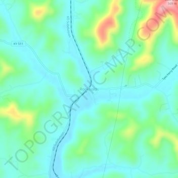
Name: Rockholds topographic map, elevation, terrain.
Location: Rockholds, Whitley County, Kentucky, United States (36.80870 -84.13632 36.84870 -84.09632)
Average elevation: 348 m
Minimum elevation: 289 m
Maximum elevation: 545 m
Other topographic maps
Click on a map to view its topography, its elevation and its terrain.
Balltown
United States > Kentucky > Whitley County > Williamsburg
Balltown, Williamsburg, Whitley County, Kentucky, 40769, United States
Average elevation: 332 m
S&J Garden
United States > Kentucky > Whitley County > Corbin
S&J Garden, Corbin, Whitley County, Kentucky, United States
Average elevation: 344 m
Corbin
United States > Kentucky > Whitley County
Corbin, Whitley County, Kentucky, 40702, United States
Average elevation: 360 m
Williamsburg
United States > Kentucky > Whitley County
Williamsburg, Whitley County, Kentucky, 40769, United States
Average elevation: 322 m