
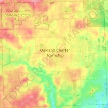
Oakland Charter Township topographic map
Interactive map
Click on the map to display elevation.
About this map
Name: Oakland Charter Township topographic map, elevation, terrain.
Average elevation: 284 m
Minimum elevation: 235 m
Maximum elevation: 328 m
Other topographic maps
Click on a map to view its topography, its elevation and its terrain.
Dollar Lake
United States > Michigan > Oakland County > Independence Charter Township
Average elevation: 306 m
Carpenter Lake Nature Preserve
United States > Michigan > Oakland County > Southfield
Average elevation: 207 m
Oxbow
United States > Michigan > Oakland County > White Lake Charter Township
Average elevation: 293 m
Huron Heights
United States > Michigan > Oakland County > Waterford Charter Township
Average elevation: 292 m
Union Lake
United States > Michigan > Oakland County > White Lake Charter Township
Average elevation: 290 m
Davisburg
United States > Michigan > Oakland County > Springfield Charter Township
Average elevation: 309 m
Rochester Hills
United States > Michigan > Oakland County > Rochester Hills
Rochester Hills is bordered to the north by Oakland Charter Township along Dutton Road, to the south by the city of Troy along South Boulevard, to the east by Shelby Township in Macomb County along Dequindre Road, and to the west by the city of Auburn Hills along part of Adams Road. Rochester Hills is also…
Average elevation: 246 m