
Make a donation
Gear up for your next adventure:
As an Amazon Associate, this site earns from qualifying purchases at no extra cost to you.
Atlantis topographic map
Click on the map to display elevation.
Gear up for your next adventure:
As an Amazon Associate, this site earns from qualifying purchases at no extra cost to you.
About this map
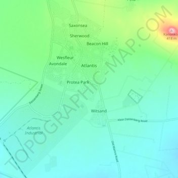
Name: Atlantis topographic map, elevation, terrain.
Location: Atlantis, City of Cape Town, Western Cape, South Africa (-33.61411 18.45315 -33.53984 18.51740)
Average elevation: 162 m
Minimum elevation: 99 m
Maximum elevation: 413 m
Make a donation
Gear up for your next adventure:
As an Amazon Associate, this site earns from qualifying purchases at no extra cost to you.
Other topographic maps
Click on a map to view its topography, its elevation and its terrain.
Beaulie Crescent Park
South Africa > Western Cape > City of Cape Town > Somerset West
Average elevation: 161 m
Make a donation
Gear up for your next adventure:
As an Amazon Associate, this site earns from qualifying purchases at no extra cost to you.
Company Gardens Pond
South Africa > Western Cape > City of Cape Town > Cape Town
Average elevation: 82 m
Make a donation
Gear up for your next adventure:
As an Amazon Associate, this site earns from qualifying purchases at no extra cost to you.
Bokkemanskloof
South Africa > Western Cape > City of Cape Town > Hout Bay > Bokkemanskloof
Average elevation: 261 m