
Atlantis topographic map
Interactive map
Click on the map to display elevation.
About this map
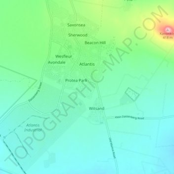
Name: Atlantis topographic map, elevation, terrain.
Location: Atlantis, City of Cape Town, Western Cape, South Africa (-33.61411 18.45315 -33.53984 18.51740)
Average elevation: 162 m
Minimum elevation: 99 m
Maximum elevation: 413 m
Other topographic maps
Click on a map to view its topography, its elevation and its terrain.
Cape Point
South Africa > Western Cape > City of Cape Town
The new lighthouse is at a lower elevation (87 meters; 285.5 feet above sea level), for two reasons: the old lighthouse, located at 34°21′12″S 18°29′25.2″E / 34.35333°S 18.490333°E / -34.35333; 18.490333 (262 meters; 859.6 feet above sea level), could be seen 'too early' by ships rounding…
Average elevation: 8 m
Beaulie Crescent Park
South Africa > Western Cape > City of Cape Town > Somerset West
Average elevation: 161 m
Company Gardens Pond
South Africa > Western Cape > City of Cape Town > Cape Town
Average elevation: 82 m
Bokkemanskloof
South Africa > Western Cape > City of Cape Town > Hout Bay > Bokkemanskloof
Average elevation: 261 m