
Grächen topographic map
Interactive map
Click on the map to display elevation.
About this map
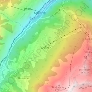
Name: Grächen topographic map, elevation, terrain.
Location: Grächen, Visp, Wallis, 3925, Switzerland (46.17343 7.81783 46.22015 7.87375)
Average elevation: 1,757 m
Minimum elevation: 834 m
Maximum elevation: 3,017 m
The village is situated at an altitude of 1,620 meters (5,310 ft) on a terrace above St. Niklaus in the Mattertal, north of the Mischabel range (and Dom).
Other topographic maps
Click on a map to view its topography, its elevation and its terrain.
Matterhorn
Switzerland > Wallis > Visp > Zermatt
Matterhorn, Zermatt, Visp, Wallis, 3920, Switzerland
Average elevation: 3,295 m
Zermatt
Switzerland > Wallis > Visp
Zermatt, Visp, Wallis, 3920, Switzerland
Average elevation: 2,921 m
Monte Rosa
Switzerland > Wallis > Visp > Zermatt
Monte Rosa, Zermatt, Visp, Wallis, 3920, Switzerland
Average elevation: 4,033 m
Saas-Almagell
Switzerland > Wallis > Visp
Saas-Almagell, Visp, Wallis, 3905, Switzerland
Average elevation: 2,830 m
St. Niklaus
Switzerland > Wallis > Visp
St. Niklaus, Visp, Wallis, 3924, Switzerland
Average elevation: 2,459 m
Mattertal
Switzerland > Wallis > Visp > St. Niklaus
Mattertal, St. Niklaus, Visp, Wallis, 3924, Switzerland
Average elevation: 2,434 m
Gorner Glacier
Switzerland > Wallis > Visp > Zermatt
Gorner Glacier, Zermatt, Visp, Wallis, 3920, Switzerland
Average elevation: 3,177 m
Dom
Switzerland > Wallis > Visp > Saas-Fee
Dom, Saas-Fee, Visp, Wallis, 3906, Switzerland
Average elevation: 3,785 m
Gornera
Switzerland > Wallis > Visp > Zermatt
Gornera, Zermatt, Visp, Wallis, 3920, Switzerland
Average elevation: 2,226 m
Saas-Fee
Switzerland > Wallis > Visp
Saas-Fee, Visp, Wallis, 3906, Switzerland
Average elevation: 2,673 m
Blatten
Switzerland > Wallis > Visp > Zermatt
Blatten, Zermatt, Visp, Wallis, 3920, Switzerland
Average elevation: 2,149 m
Allalinhorn
Switzerland > Wallis > Visp > Saas-Fee
Allalinhorn, Saas-Fee, Visp, Wallis, 3906, Switzerland
Average elevation: 3,490 m