
Make a donation
Gear up for your next adventure:
As an Amazon Associate, this site earns from qualifying purchases at no extra cost to you.
Dubai topographic map
Click on the map to display elevation.
Make a donation
Gear up for your next adventure:
As an Amazon Associate, this site earns from qualifying purchases at no extra cost to you.
Dubai
Dubai lies directly within the Arabian Desert. However, the topography of Dubai is significantly different from that of the southern portion of the UAE in that much of Dubai's landscape is highlighted by sandy desert patterns, while gravel deserts dominate much of the southern region of the country. The sand consists mostly of crushed shell and coral and is fine, clean and white. East of the city, the salt-crusted coastal plains, known as sabkha, give way to a north-south running line of dunes. Farther east, the dunes grow larger and are tinged red with iron oxide.
Make a donation
Gear up for your next adventure:
As an Amazon Associate, this site earns from qualifying purchases at no extra cost to you.
About this map
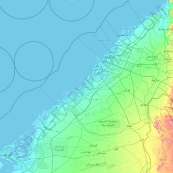
Name: Dubai topographic map, elevation, terrain.
Location: Dubai, United Arab Emirates (24.62307 54.45646 25.52507 56.20362)
Average elevation: 79 m
Minimum elevation: -11 m
Maximum elevation: 1,052 m
Make a donation
Gear up for your next adventure:
As an Amazon Associate, this site earns from qualifying purchases at no extra cost to you.
Other topographic maps
Click on a map to view its topography, its elevation and its terrain.
Dubai
Dubai lies directly within the Arabian Desert. However, the topography of Dubai is significantly different from that of the southern portion of the UAE in that much of Dubai's landscape is highlighted by sandy desert patterns, while gravel deserts dominate much of the southern region of the country. The sand…
Average elevation: 7 m
Make a donation
Gear up for your next adventure:
As an Amazon Associate, this site earns from qualifying purchases at no extra cost to you.
Make a donation
Gear up for your next adventure:
As an Amazon Associate, this site earns from qualifying purchases at no extra cost to you.
Make a donation
Gear up for your next adventure:
As an Amazon Associate, this site earns from qualifying purchases at no extra cost to you.
Make a donation
Gear up for your next adventure:
As an Amazon Associate, this site earns from qualifying purchases at no extra cost to you.
Make a donation
Gear up for your next adventure:
As an Amazon Associate, this site earns from qualifying purchases at no extra cost to you.
Make a donation
Gear up for your next adventure:
As an Amazon Associate, this site earns from qualifying purchases at no extra cost to you.
Jabal Hafeet
United Arab Emirates > Abu Dhabi Emirate > Al Ain > Jabal Hafeet
Average elevation: 610 m
Make a donation
Gear up for your next adventure:
As an Amazon Associate, this site earns from qualifying purchases at no extra cost to you.
Green Mubazzarah Park
United Arab Emirates > Abu Dhabi Emirate > Al Ain > Mbazzarah Al Khadra
Average elevation: 305 m
Make a donation
Gear up for your next adventure:
As an Amazon Associate, this site earns from qualifying purchases at no extra cost to you.
Al Ain
United Arab Emirates > Abu Dhabi Emirate > Al Ain > Al Mutaredh
Al Ain is located approximately 160 kilometres (99 mi) east of the capital Abu Dhabi, and about 120 kilometres (75 mi) south of Dubai. The eastern region covers an area of approximately 13,100 km2 (5,100 sq mi). Oman lies to the east, Dubai and Sharjah to the north, Abu Dhabi to the west and the Empty Quarter…
Average elevation: 294 m
Make a donation
Gear up for your next adventure:
As an Amazon Associate, this site earns from qualifying purchases at no extra cost to you.
Make a donation
Gear up for your next adventure:
As an Amazon Associate, this site earns from qualifying purchases at no extra cost to you.
Make a donation
Gear up for your next adventure:
As an Amazon Associate, this site earns from qualifying purchases at no extra cost to you.
Make a donation
Gear up for your next adventure:
As an Amazon Associate, this site earns from qualifying purchases at no extra cost to you.
Al Fay Forest Park
United Arab Emirates > Abu Dhabi Emirate > Abu Dhabi > Abu Dhabi
Average elevation: 2 m
Make a donation
Gear up for your next adventure:
As an Amazon Associate, this site earns from qualifying purchases at no extra cost to you.
Hatta
Due to Hatta's higher altitude, its climate is much cooler than central Dubai. Hatta has an arid landscape and temperature, reaching 55 degrees Celsius in the summer; however, it is less humid than Dubai and far colder in the winter.
Average elevation: 371 m
Sha'biyyat Ash Shiweb
United Arab Emirates > Abu Dhabi Emirate > Al Ain > Al Shiwayb
Average elevation: 278 m
Al Ain
United Arab Emirates > Abu Dhabi Emirate > Al Ain > Al Mutaredh
The city is located approximately 160 kilometres (99 mi) east of the capital Abu Dhabi, and about 120 kilometres (75 mi) south of Dubai. The eastern region covers an area of approximately 13,100 km2 (5,100 sq mi). Oman lies to the east, Dubai and Sharjah to the north, Abu Dhabi to the west and the Empty…
Average elevation: 294 m
Make a donation
Gear up for your next adventure:
As an Amazon Associate, this site earns from qualifying purchases at no extra cost to you.
Sha'biyyat As Silēmāt
United Arab Emirates > Abu Dhabi Emirate > Al Ain > Al Salamat
Average elevation: 233 m
Make a donation
Gear up for your next adventure:
As an Amazon Associate, this site earns from qualifying purchases at no extra cost to you.
Make a donation
Gear up for your next adventure:
As an Amazon Associate, this site earns from qualifying purchases at no extra cost to you.
Make a donation
Gear up for your next adventure:
As an Amazon Associate, this site earns from qualifying purchases at no extra cost to you.
Al Ain
United Arab Emirates > Abu Dhabi Emirate > Al Ain
The city is located approximately 160 kilometres (99 mi) east of the capital Abu Dhabi, and about 120 kilometres (75 mi) south of Dubai. The eastern region covers an area of approximately 13,100 km2 (5,100 sq mi). Oman lies to the east, Dubai and Sharjah to the north, Abu Dhabi to the west and the Empty…
Average elevation: 294 m
Make a donation
Gear up for your next adventure:
As an Amazon Associate, this site earns from qualifying purchases at no extra cost to you.
Sha'biyyat Al Hiyar
United Arab Emirates > Abu Dhabi Emirate > Al Ain > Al Hiyar
Average elevation: 303 m
Make a donation
Gear up for your next adventure:
As an Amazon Associate, this site earns from qualifying purchases at no extra cost to you.
Make a donation
Gear up for your next adventure:
As an Amazon Associate, this site earns from qualifying purchases at no extra cost to you.
Make a donation
Gear up for your next adventure:
As an Amazon Associate, this site earns from qualifying purchases at no extra cost to you.
Wadi Kub
United Arab Emirates > Ras al-Khaimah > Kub
In its upper course, the wadi is formed by two arms of similar length and flow, which originate at approximately an altitude of 542 m (1,778 ft); they border Al Jaroof to the east and west, respectively; and converge to the south of this town, defining the main channel, which initially follows the direction…
Average elevation: 324 m
Make a donation
Gear up for your next adventure:
As an Amazon Associate, this site earns from qualifying purchases at no extra cost to you.
Shi'bat Al Wutah
United Arab Emirates > Abu Dhabi Emirate > Al Ain > Shi'bat Al Wutah
Average elevation: 255 m
Hatta
Due to Hatta's higher altitude, its climate is much cooler than central Dubai. Hatta has an arid landscape and temperature, reaching 55 degrees Celsius in the summer; however, it is less humid than Dubai and far colder in the winter.
Average elevation: 371 m
Make a donation
Gear up for your next adventure:
As an Amazon Associate, this site earns from qualifying purchases at no extra cost to you.
Make a donation
Gear up for your next adventure:
As an Amazon Associate, this site earns from qualifying purchases at no extra cost to you.
Make a donation
Gear up for your next adventure:
As an Amazon Associate, this site earns from qualifying purchases at no extra cost to you.