
Gander topographic map
Interactive map
Click on the map to display elevation.
About this map
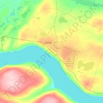
Name: Gander topographic map, elevation, terrain.
Location: Gander, Newfoundland, Newfoundland and Labrador, Canada (48.88498 -54.72110 49.00797 -54.49882)
Average elevation: 100 m
Minimum elevation: 19 m
Maximum elevation: 220 m
Other topographic maps
Click on a map to view its topography, its elevation and its terrain.
Pee Pee Island
Canada > Newfoundland and Labrador > unincorporated Newfoundland
Average elevation: 16 m
Fogo Island
Canada > Newfoundland and Labrador > Joe Batt's Arm-Barr'd Islands-Shoal Bay
Average elevation: 3 m