
Bảo Lâm District topographic map
Interactive map
Click on the map to display elevation.
About this map
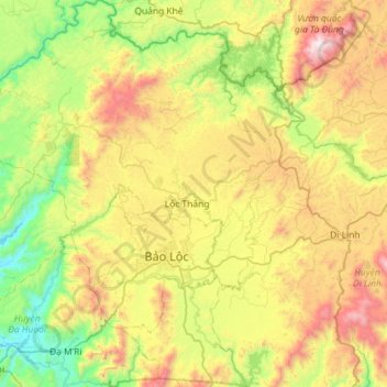
Name: Bảo Lâm District topographic map, elevation, terrain.
Location: Bảo Lâm District, Lâm Đồng Province, Vietnam (11.35962 107.48372 11.92229 107.96792)
Average elevation: 787 m
Minimum elevation: 143 m
Maximum elevation: 1,943 m
Other topographic maps
Click on a map to view its topography, its elevation and its terrain.
Clearest Water in Vietnam
Vietnam > Lâm Đồng Province > Bảo Lâm District > Bảo Lộc
Average elevation: 858 m
Bản Đơng Mang
Vietnam > Lâm Đồng Province > Lạc Dương District > Bản Đơng Mang
Average elevation: 1,597 m