
Brazos River topographic map
Interactive map
Click on the map to display elevation.
About this map
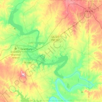
Name: Brazos River topographic map, elevation, terrain.
Location: Brazos River, Hood County, Texas, 76048, United States (32.31396 -97.83355 32.55753 -97.60337)
Average elevation: 256 m
Minimum elevation: 179 m
Maximum elevation: 375 m
Other topographic maps
Click on a map to view its topography, its elevation and its terrain.
Houston
United States > Texas > Harris County
Houston is characterized by its predominantly flat topography, sitting at an average elevation of approximately 59 feet (18 meters) above sea level. The city is situated on the Gulf Coastal Plain, which is dissected by a network of bayous that contribute to the region's drainage. This terrain was once covered…
Average elevation: 25 m
Austin
United States > Texas > Travis County
Austin features a diverse and varied topography shaped by its position along the Balcones Fault. The city’s elevation ranges from about 425 feet to approximately 1,000 feet above sea level, creating a landscape characterized by rolling hills and elevated areas particularly in the western regions. To the…
Average elevation: 216 m
El Paso
United States > Texas > El Paso County
El Paso is characterized by a diverse and striking topography shaped by its desert environment and mountainous landscapes. The city is situated at an average elevation of approximately 3,700 feet above sea level, surrounded by the rugged Franklin Mountains to the west, where peaks exceed 7,000 feet. This…
Average elevation: 1,237 m
Austin
United States > Texas > Travis County
The elevation of Austin varies from 425 feet (130 m) to approximately 1,000 feet (305 m) above sea level. Due to the fact it straddles the Balcones Fault, much of the eastern part of the city is flat, with heavy clay and loam soils, whereas the western part and western suburbs consist of rolling hills on the…
Average elevation: 216 m
Dallas
United States > Texas > Dallas County
Dallas features a predominantly flat terrain characterized by elevations generally ranging from 450 to 550 feet (137 to 168 meters) above sea level. The landscape is shaped significantly by the western edge of the Austin Chalk Formation, a limestone escarpment known as the White Rock Escarpment, which rises…
Average elevation: 160 m
Dallas
United States > Texas > Dallas County
Dallas and its surrounding area are mostly flat. The city lies at elevations ranging from 450 to 550 feet (137 to 168 m) above sea level. The western edge of the Austin Chalk Formation, a limestone escarpment (also known as the "White Rock Escarpment"), rises 230 feet (70 m) and runs roughly north–south…
Average elevation: 160 m
Denton
United States > Texas > Denton County
Denton is on the northern edge of the Dallas–Fort Worth metropolitan area. These three cities form the area known as the "Golden Triangle of North Texas". According to the United States Census Bureau, the city has an area of 89.316 square miles (231.33 km2), of which 87.952 square miles (227.79 km2) is land…
Average elevation: 195 m
Plano
United States > Texas > Collin County
At first, Plano's population grew slowly, reaching 1,304 in 1900 and 3,695 in 1960. By 1970, Plano began to feel some of the boom its neighbors had experienced after World War II. A series of public works projects and a change in taxes that removed the farming community from the town helped increase the…
Average elevation: 196 m
Houston
United States > Texas > Harris County
Houston is characterized by its predominantly flat topography, sitting at an average elevation of approximately 59 feet (18 meters) above sea level. The city is situated on the Gulf Coastal Plain, which is dissected by a network of bayous that contribute to the region's drainage. This terrain was once covered…
Average elevation: 25 m
Van Zandt County
According to the U.S. Census Bureau, the county has a total area of 860 sq mi (2,200 km2), of which 17 square miles (44 km2) (2.0%) are covered by water. Van Zandt County is unique in topography. The western and northwestern parts of the county are in the eastern edge of the Texas Blackland Prairies, the…
Average elevation: 141 m
Amarillo
United States > Texas > Potter County
Amarillo features a unique topography characterized by its high elevation and flat plains. The city averages around 3,600 feet (1,097 meters) above sea level, making it one of the highest major cities in Texas. The surrounding landscape consists of the Llano Estacado, a vast tabletop plateau that slopes…
Average elevation: 1,097 m
Kerrville
United States > Texas > Kerr County
Kerrville is characterized by a diverse and rugged topography. Nestled along the Guadalupe River, it sits at an elevation averaging 1,600 feet above sea level, with varying terrain that includes gentle hills, steep slopes, and flat river valleys. This area features numerous limestone hills, characteristic of…
Average elevation: 545 m
San Antonio
United States > Texas > Bexar County
San Antonio features a diverse topography characterized by gently rolling hills and flat plains. The city's elevation averages around 650 feet above sea level, but nearby areas can reach heights of up to 1,300 feet in certain locations like Cross Mountain. The landscape is part of the southern edge of the…
Average elevation: 247 m
Lubbock
United States > Texas > Lubbock County
Summers are hot, with 78 afternoons on average of 90 °F (32.2 °C)+ highs and 7.4 afternoons of 100 °F (37.8 °C)+ highs, although due to the aridity and elevation, temperatures remain above 70 °F (21.1 °C) on only a few mornings. Lubbock is the 10th-windiest city in the US with an average wind speed of…
Average elevation: 983 m
Georgetown
United States > Texas > Williamson County
Georgetown lies in the central part of Williamson County and features a diverse topography influenced by the Balcones Escarpment. The city itself sits at an average elevation of about 800 feet (244 meters), with its terrain ranging from flatter areas in the east to more hilly and karst-like features in the…
Average elevation: 247 m
Corpus Christi
United States > Texas > Nueces County
Corpus Christi features a diverse coastal topography characterized by its proximity to the Gulf of Mexico. The landscape includes sandy beaches, barrier islands, and extensive estuarine systems such as the Nueces Estuary and Corpus Christi Bay, which are crucial habitats for wildlife. The region is…
Average elevation: 8 m
Port Arthur
United States > Texas > Jefferson County
Port Arthur sits in a low-lying coastal area of the Gulf Coast, characterized by its flat, marshy terrain. The city is located at an average elevation of just 8 feet (2 meters) above sea level, with parts of the surrounding region even closer to sea level. Its topography is dominated by wetlands, tidal…
Average elevation: 2 m
Montgomery County
Montgomery County features a predominantly flat terrain, with average elevations ranging from about 100 to 350 feet above sea level. The landscape is gently rolling, particularly towards the northern areas, and is interspersed with several lakes, such as the expansive Lake Conroe. This large reservoir, formed…
Average elevation: 69 m
Conroe
United States > Texas > Montgomery County
Conroe features a predominantly flat terrain with an average elevation of approximately 220 feet (67 meters) above sea level. The area is characterized by gently rolling hills interspersed with numerous lakes and wetlands, including the prominent Lake Conroe, which spans about 21,000 acres. The lake, formed by…
Average elevation: 62 m
The Woodlands
United States > Texas > Montgomery County
The Woodlands is in a heavily forested area, and much of the community has retained trees for shade and decoration. The terrain is essentially flat, with the exception of topographic variations ranging from 125 to 175 feet above sea level between Spring Creek and Flintridge Drive.
Average elevation: 47 m
Fredericksburg
United States > Texas > Gillespie County
Enchanted Rock is a geographical landmark 27 km (17 mi) north of Fredericksburg in Llano County. The rock is a huge, pink granite exfoliation dome that rises 425 ft (130 m) above the surrounding land, has a summit elevation of 1,825 ft (556 m) above sea level, and covers 640 acres (260 ha). Enchanted Rock…
Average elevation: 526 m
Rockport
United States > Texas > Aransas County
The topography of Rockport, Texas, is defined by its flat, coastal terrain, with the city's average elevation being around 20 feet above sea level. The land is largely shaped by the proximity to the Gulf of Mexico, which influences the area's low-lying nature, including some areas below sea level. The…
Average elevation: 3 m
San Marcos
United States > Texas > Hays County
San Marcos is characterized by its diverse topography, which includes rolling hills, lush riverbanks, and scenic limestone outcroppings. The city is situated at an elevation of approximately 600 feet above sea level, providing a backdrop of gently undulating terrain that slopes towards the banks of the San…
Average elevation: 208 m
Travis County
Travis County features a varied and dynamic topography characterized by rolling hills, lush valleys, and significant water features. The terrain rises gently from the flatlands in the east to the more rugged and elevated areas in the west, reaching elevations of up to about 1,400 feet above sea level. The…
Average elevation: 231 m
McLennan County
McLennan County is characterized by its gently rolling terrain and a mix of landscapes that define its topography. The county's average elevation is approximately 600 feet above sea level, with variations across its landscape influenced by the presence of rivers and creeks, notably the Bosque River and the…
Average elevation: 181 m
Frisco
United States > Texas > Collin County
In 1902, a line of the St. Louis-San Francisco Railway was being built through the area, and periodic watering stops were needed along the route for the steam locomotives. The current settlement of Lebanon was on the Preston Ridge, and was too high in elevation, so the watering stop was placed about 4 miles (6…
Average elevation: 201 m
Cedar Hill
United States > Texas > Dallas County
The city is sometimes referred to as the "hill country of Dallas" (in comparison to the "hill country" surrounding Austin and San Antonio). The city is full of native eastern red cedar evergreen trees and stands at an elevation of about 800 feet (240 m) above sea level—the highest point in a straight line…
Average elevation: 214 m
Emory Peak
United States > Texas > Brewster County
The peak can be reached by a moderate hike on a well-marked path across steep rocky terrain with an elevation gain of approximately 2,500 feet (760 m). The Emory Peak Trail is about 1.5 miles (2.4 km) long. The trail is reached by climbing the Pinnacles Trail 3.5 miles (5.6 km) from the Chisos Basin trailhead.…
Average elevation: 2,061 m
Lewisville
United States > Texas > Denton County
Lewisville is at 33°2′18″N 97°0′22″W / 33.03833°N 97.00611°W / 33.03833; -97.00611 (33.038316, −97.006232) at an elevation of about 550 feet (170 m). It has a total area of 42.5 square miles (110 km2), of which 6.1 sq mi (16 km2) is covered by water. It lies at the southern end of Denton…
Average elevation: 160 m