
Sirohi topographic map
Interactive map
Click on the map to display elevation.
About this map
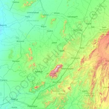
Name: Sirohi topographic map, elevation, terrain.
Location: Sirohi, Sirohi District, Rajasthan, 307001, India (24.13333 72.05000 25.53333 73.45000)
Average elevation: 315 m
Minimum elevation: 68 m
Maximum elevation: 1,659 m
Other topographic maps
Click on a map to view its topography, its elevation and its terrain.
Pokaran
India > Rajasthan > Pokaran Tehsil
Pokhran is located 112 km east of Jaisalmer city, 172 km northwest of Jodhpur and 225 km south of Bikaner by road. It lies on Jaisalmer to Jodhpur railway line. It is situated at 27°05′42″N 71°45′11″E / 27.095°N 71.753°E / 27.095; 71.753 and has an average elevation of 233 metres (764 feet).
Average elevation: 229 m
Jalore
The district is bounded on the northwest by Barmer District, on the northeast by Pali District, on the southeast by Sirohi District, and by Banaskantha District of Gujarat state on the southwest. The total area of the district is 10,640 km2 (4,108 sq mi). The altitude is 268 m, latitude is 25.22 N and…
Average elevation: 183 m
Hindaun
India > Rajasthan > Hindaun Tehsil
Hindaun has an average elevation of 235 metres (771 ft). Its distance from the state capital of Jaipur is around 150 km.
Average elevation: 230 m
Sirohi
India > Rajasthan > Sirohi Tehsil
Sirohi is located at 24°53′06″N 72°51′45″E / 24.885°N 72.8625°E / 24.885; 72.8625. It has an average elevation of 321 metres (1053 ft).
Average elevation: 321 m
Dausa
The general topographic elevation in the district is between 250 m to 300 m above sea level. Elevation ranges from a minimum of 203.2 m above sea level in Mahwa in the northeastern part of the district and maximum of 596.3 m above sea level in Bandikui in northern part of the district.
Average elevation: 313 m
karauli
India > Rajasthan > Karauli Tehsil
Karauli is located at 26°30′N 77°01′E / 26.5°N 77.02°E / 26.5; 77.02. It has an average elevation of 275 metres (902 ft).
Average elevation: 273 m
Karauli
The Chambal River forms the south-eastern boundary of the district, 5 km from Mandrayal across which lies the state of Madhya Pradesh. While almost the entire district is covered by hills and ravines, there are no lofty peaks, the highest having an elevation of less than 1400 feet above sea level.
Average elevation: 263 m
Nagaur District
The vegetation consists of a sparse cover of thorny woodland with distinct variations in different topographical areas. The principal trees found on sand dunes are Prosopis cineraria, Acacia senegal, Tecomella undulata, Gymnosporia and Aerva.
Average elevation: 314 m
Baran District
Baran is located at 25°06′N 76°31′E / 25.1°N 76.52°E / 25.1; 76.52. It has an average elevation of 262 metres (859 feet). Located in the Kota Plateau of Vindhya range, district is the location of famous Ramgarh crater made from the meteorite strike.
Average elevation: 333 m
Jaipur Municipal Corporation
India > Rajasthan > Jaipur Municipal Corporation
Average elevation: 411 m
Chittorgarh Fort
India > Rajasthan > Chittaurgarh Tehsil > Chittauri > Chittauri Ka Khera
Average elevation: 427 m