
Make a donation
Gear up for your next adventure:
As an Amazon Associate, this site earns from qualifying purchases at no extra cost to you.
Sauerland topographic map
Click on the map to display elevation.
Gear up for your next adventure:
As an Amazon Associate, this site earns from qualifying purchases at no extra cost to you.
Sauerland
To the west the hills continue into the Bergisches Land, to the south into the Siegerland, and to the north-east into the Teutoburg Forest. The major rivers of the Sauerland are the Ruhr and the Lenne. Several artificial lakes were created on the smaller rivers by building dams to store water for the nearby Ruhr area, the biggest reservoirs being the Möhne and Bigge. Although the highest elevation of the Sauerland is the Langenberg (843 m) near Olsberg, the much more renowned summit, which is well known for the nearby skiing facilities, its weather station and observation tower, is the slightly lower Kahler Asten (842 m) near Winterberg. Both Langenberg and Kahler Asten are peaks in the Rothaargebirge mountains.
Make a donation
Gear up for your next adventure:
As an Amazon Associate, this site earns from qualifying purchases at no extra cost to you.
About this map
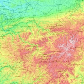
Name: Sauerland topographic map, elevation, terrain.
Location: Sauerland, North Rhine-Westphalia, Germany (50.92129 7.42669 51.59645 8.92098)
Average elevation: 316 m
Minimum elevation: 41 m
Maximum elevation: 844 m
Make a donation
Gear up for your next adventure:
As an Amazon Associate, this site earns from qualifying purchases at no extra cost to you.
Other topographic maps
Click on a map to view its topography, its elevation and its terrain.
Gelstern
Germany > North Rhine-Westphalia > Märkischer Kreis > Schalksmühle > Heedfeld
Average elevation: 385 m
Aachen
Germany > North Rhine-Westphalia > Aachen (district)
The maximum dimensions of the city's territory are 21.6 km (13+3⁄8 mi) from north to south, and 17.2 km (10+3⁄4 mi) from east to west. The city limits are 87.7 km (54+1⁄2 mi) long, of which 23.8 km (14+3⁄4 mi) border Belgium and 21.8 km (13+1⁄2 mi) the Netherlands. The highest point in Aachen,…
Average elevation: 225 m
Rotthausen
Germany > North Rhine-Westphalia > Märkischer Kreis > Schalksmühle
Average elevation: 343 m
Make a donation
Gear up for your next adventure:
As an Amazon Associate, this site earns from qualifying purchases at no extra cost to you.
Essen
Germany > North Rhine-Westphalia
The lowest point can be found in the northern borough of Karnap at 26.5 metres (86.9 ft), the highest point in the borough of Heidhausen at 202.5 metres (664 ft). The average elevation is 116 metres (381 ft).
Average elevation: 86 m
Reineberg
Germany > North Rhine-Westphalia > Kreis Minden-Lübbecke > Lübbecke
The Reineberg is a hill on the Wiehen ridge, south of the town of Lübbecke. With a height of 275.9 m above sea level it is, from a topographical point of view, not a particularly impressive eminence in this part of the Wiehen Hills, because, in the immediate vicinity are considerably higher summits, such as…
Average elevation: 181 m
Make a donation
Gear up for your next adventure:
As an Amazon Associate, this site earns from qualifying purchases at no extra cost to you.
Erlinghausen
Germany > North Rhine-Westphalia > Hochsauerlandkreis > Marsberg
Average elevation: 360 m
Make a donation
Gear up for your next adventure:
As an Amazon Associate, this site earns from qualifying purchases at no extra cost to you.
Make a donation
Gear up for your next adventure:
As an Amazon Associate, this site earns from qualifying purchases at no extra cost to you.
Ruhr
Germany > North Rhine-Westphalia
The source of the Ruhr is near the town of Winterberg in the mountainous Sauerland region, at an elevation of approximately 670 metres (2,200 ft). It flows into the lower Rhine at an elevation of only 17 metres (56 ft) in the municipal area of Duisburg. Its total length is 219 km (136 mi), its average…
Average elevation: 209 m
Bergisch Gladbach
Germany > North Rhine-Westphalia > Rheinisch-Bergischer Kreis
Average elevation: 115 m
Make a donation
Gear up for your next adventure:
As an Amazon Associate, this site earns from qualifying purchases at no extra cost to you.
Teutoburg Forest
Germany > North Rhine-Westphalia > Kreis Gütersloh
The highest elevation in the Southern Teutoburg Forest is the Velmerstot (468 m or 1,535 ft) south of Horn-Bad Meinberg. In the Northern Teutoburg Forest the highest elevation is the Dörenberg (331 m or 1,086 ft) north of Bad Iburg.
Average elevation: 105 m
Make a donation
Gear up for your next adventure:
As an Amazon Associate, this site earns from qualifying purchases at no extra cost to you.
Lützinghausen
Germany > North Rhine-Westphalia > Oberbergischer Kreis > Gummersbach
Average elevation: 310 m
Winterberg
Germany > North Rhine-Westphalia > Hochsauerlandkreis
Winterberg experiences a humid continental climate (Köppen Dfb) like most of Germany, however also bordering on subarctic climate (Dfc), thanks to its altitude, with only having an average temperature above 10 °C and September only being barely above it. The summers are short and cool, while the winters are…
Average elevation: 628 m
Lippe
Germany > North Rhine-Westphalia
The Lippe (German pronunciation: [ˈlɪpə] ) is a river in North Rhine-Westphalia, Germany. It is a right tributary of the Rhine and 220.3 km (136.9 mi) in length with an elevation difference of 125 metres and a catchment area of 4.890 km². The source is located at the edge of the Teutoburg Forest in Bad…
Average elevation: 161 m
Make a donation
Gear up for your next adventure:
As an Amazon Associate, this site earns from qualifying purchases at no extra cost to you.
Aachen
Germany > North Rhine-Westphalia > Aachen (district)
The maximum dimensions of the city's territory are 21.6 km (13+3⁄8 mi) from north to south, and 17.2 km (10+3⁄4 mi) from east to west. The city limits are 87.7 km (54+1⁄2 mi) long, of which 23.8 km (14+3⁄4 mi) border Belgium and 21.8 km (13+1⁄2 mi) the Netherlands. The highest point in Aachen,…
Average elevation: 225 m
Borner
Germany > North Rhine-Westphalia > Oberbergischer Kreis > Reichshof > Nosbach
Average elevation: 389 m
Make a donation
Gear up for your next adventure:
As an Amazon Associate, this site earns from qualifying purchases at no extra cost to you.
Velbert
Germany > North Rhine-Westphalia > Kreis Mettmann
Velbert stands on the highest part of the Niederberg region and also in its centre. Its average elevation is around 230 metres above sea level; its highest point, at 303 metres, is the Hordt-Berg, and its lowest, at around 70.6 metres, is in Nierenhof am Deilbach. The highest point in Velbert itself is 263…
Average elevation: 172 m
Make a donation
Gear up for your next adventure:
As an Amazon Associate, this site earns from qualifying purchases at no extra cost to you.
Aachen
Germany > North Rhine-Westphalia > Aachen (district)
The maximum dimensions of the city's territory are 21.6 km (13+3⁄8 mi) from north to south, and 17.2 km (10+3⁄4 mi) from east to west. The city limits are 87.7 km (54+1⁄2 mi) long, of which 23.8 km (14+3⁄4 mi) border Belgium and 21.8 km (13+1⁄2 mi) the Netherlands. The highest point in Aachen,…
Average elevation: 225 m
Altastenberg
Germany > North Rhine-Westphalia > Hochsauerlandkreis > Winterberg
Average elevation: 708 m
Make a donation
Gear up for your next adventure:
As an Amazon Associate, this site earns from qualifying purchases at no extra cost to you.
Leuth
Germany > North Rhine-Westphalia > Kreis Viersen > Region Kempen-Viersen
Average elevation: 43 m
Make a donation
Gear up for your next adventure:
As an Amazon Associate, this site earns from qualifying purchases at no extra cost to you.
Make a donation
Gear up for your next adventure:
As an Amazon Associate, this site earns from qualifying purchases at no extra cost to you.
Monschau
Germany > North Rhine-Westphalia > Aachen (district)
At two meetings in the spring meet canoeists for about 50 years in Monschau international events, and a whitewater races. Nationally known is the Monschau Marathon more than 760 meters of altitude, which takes place in August.
Average elevation: 551 m
Make a donation
Gear up for your next adventure:
As an Amazon Associate, this site earns from qualifying purchases at no extra cost to you.
45663
Germany > North Rhine-Westphalia > Kreis Recklinghausen > Recklinghausen
Average elevation: 57 m
Wewelsburg
Germany > North Rhine-Westphalia > Kreis Paderborn > Büren > Wewelsburg
Average elevation: 216 m
Make a donation
Gear up for your next adventure:
As an Amazon Associate, this site earns from qualifying purchases at no extra cost to you.
Make a donation
Gear up for your next adventure:
As an Amazon Associate, this site earns from qualifying purchases at no extra cost to you.
Wahnenbusch
Germany > North Rhine-Westphalia > Kreis Heinsberg > Erkelenz > Tenholt
Average elevation: 94 m
Monschau
Germany > North Rhine-Westphalia > Aachen (district)
At two meetings in the spring meet canoeists for about 50 years in Monschau international events, and a whitewater races. Nationally known is the Monschau Marathon more than 760 meters of altitude, which takes place in August.
Average elevation: 551 m
Make a donation
Gear up for your next adventure:
As an Amazon Associate, this site earns from qualifying purchases at no extra cost to you.
51503
Germany > North Rhine-Westphalia > Rheinisch-Bergischer Kreis > Rösrath > Hoffnungsthal > Vierkotten
Average elevation: 123 m
Make a donation
Gear up for your next adventure:
As an Amazon Associate, this site earns from qualifying purchases at no extra cost to you.
Lippe
Germany > North Rhine-Westphalia
The Lippe (German pronunciation: [ˈlɪpə] ) is a river in North Rhine-Westphalia, Germany. It is a right tributary of the Rhine and 220.3 km (136.9 mi) in length with an elevation difference of 125 metres and a catchment area of 4.890 km². The source is located at the edge of the Teutoburg Forest in Bad…
Average elevation: 161 m
Make a donation
Gear up for your next adventure:
As an Amazon Associate, this site earns from qualifying purchases at no extra cost to you.
Herten
Germany > North Rhine-Westphalia > Kreis Recklinghausen
Herten covers an area of 37.31 km2, with a maximum north-south extent of 9.5 km, and a maximum east-west extent of 6.5 km. The municipality's highest natural point is in Scherlebeck, close to the border with Recklinghausen, with an altitude of 110 m.
Average elevation: 68 m
Make a donation
Gear up for your next adventure:
As an Amazon Associate, this site earns from qualifying purchases at no extra cost to you.
Breitscheid
Germany > North Rhine-Westphalia > Rhein-Sieg-Kreis > Neunkirchen-Seelscheid
Average elevation: 179 m
Castrop-Rauxel
Germany > North Rhine-Westphalia > Kreis Recklinghausen
The city covers an area of 51.67 km2 (19.95 sq mi). The Halde Schwerin (slag heap in the Schwerin district) is marked as the point of highest elevation at 147 m (482.3 ft) above sea level. The lowest point is located on Pöppinghauser Straße (Poppinghausen Street), besides house number 264, with an elevation…
Average elevation: 75 m
Make a donation
Gear up for your next adventure:
As an Amazon Associate, this site earns from qualifying purchases at no extra cost to you.
An der Manier
Germany > North Rhine-Westphalia > Kreis Kleve > Kalkar > Neulouisendorf
Average elevation: 30 m
Make a donation
Gear up for your next adventure:
As an Amazon Associate, this site earns from qualifying purchases at no extra cost to you.
Make a donation
Gear up for your next adventure:
As an Amazon Associate, this site earns from qualifying purchases at no extra cost to you.
Make a donation
Gear up for your next adventure:
As an Amazon Associate, this site earns from qualifying purchases at no extra cost to you.
Make a donation
Gear up for your next adventure:
As an Amazon Associate, this site earns from qualifying purchases at no extra cost to you.
Dusseldorf
Germany > North Rhine-Westphalia
In 1186, Düsseldorf came under the rule of the Counts of Berg. 14 August 1288 is one of the most important dates in the history of Düsseldorf, the day the sovereign Count Adolf VIII of Berg granted town privileges to the village on the banks of the Düssel. Before this, a bloody struggle for power had taken…
Average elevation: 54 m
Make a donation
Gear up for your next adventure:
As an Amazon Associate, this site earns from qualifying purchases at no extra cost to you.