
Tábor topographic map
Interactive map
Click on the map to display elevation.
Tábor
Tábor is located in the Tábor Uplands. The highest point is the Hýlačka hill with an altitude of 525 m (1,722 ft) and the lowest is the surface of the river Lužnice. The historic old town is situated on a hill above the river, which was used for the protection of the town.
About this map
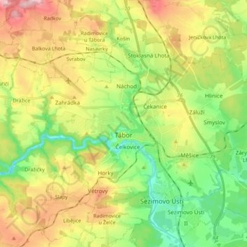
Name: Tábor topographic map, elevation, terrain.
Location: Tábor, okres Tábor, Southwest, Czechia (49.38189 14.60212 49.45642 14.76842)
Average elevation: 464 m
Minimum elevation: 376 m
Maximum elevation: 589 m
Other topographic maps
Click on a map to view its topography, its elevation and its terrain.
Historic Centre of Český Krumlov
Czechia > Southwest > South Bohemian Region > Český Krumlov
Average elevation: 542 m