
Sauchen topographic map
Interactive map
Click on the map to display elevation.
About this map
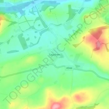
Name: Sauchen topographic map, elevation, terrain.
Location: Sauchen, Aberdeenshire, Scotland, AB51 7JU, United Kingdom (57.16879 -2.51802 57.20879 -2.47802)
Average elevation: 114 m
Minimum elevation: 77 m
Maximum elevation: 196 m
Aberdeenshire trails, hiking, mountain biking, running and outdoor activities
Other topographic maps
Click on a map to view its topography, its elevation and its terrain.
Dunnottar Castle
United Kingdom > Scotland > Aberdeenshire > Stonehaven > Mains of Dunnottar
Average elevation: 33 m
Glen Tanar
United Kingdom > Scotland > Aberdeenshire > Aboyne
Glen Tanar, along with the side glens formed by the Water of Gairney and the Water of Allachy, comprises the third largest area of Caledonian Forest in Scotland, which grows from the valley floor up to an altitude of 450 metres. As a Caledonian Forest, the predominant tree species is Scots pine, although…
Average elevation: 389 m